
Guinea: 170-km Coyah-Kindia-Mamou Highway Launches 855-km Road Corridor to Côte d’Ivoire
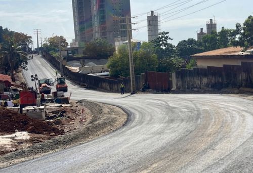
Road transport in Guinea: the country launched construction of the 170-km Coyah-Kindia-Mamou highway on 24 August 2026. The first section is intended to increase transport capacity between Conakry and inland regions as part of an 855-km corridor planned to reach the Ivorian border.
A 170-km highway to strengthen road transport in Guinea
The Coyah-Kindia-Mamou project is the first phase of Guinea’s Southern Corridor. The route is ultimately expected to connect Conakry with the Côte d’Ivoire border through Faranah, Kissidougou, Kérouané, Beyla and Sinko.
The highway will be built as a dual carriageway with two lanes in each direction. It will include interchanges, automated toll and weighing stations, rest areas and road-safety infrastructure.
Operationally, the project is designed to improve traffic flow on a route facing growing demand. Expansion around Greater Conakry is increasing transport needs, while mining activity in Forécariah, Kindia and Beyla is generating additional requirements for freight and input movements.
The corridor is also expected to improve access to agricultural production areas and tourism sites along the route. For carriers, the main operational issues are expected to be more predictable travel times, additional road capacity and lower vehicle operating costs linked to poor road conditions.
Road infrastructure in Guinea still constrained by maintenance gaps
Guinea has approximately 45,300 km of roads, including 7,576 km of national roads. Of these, 2,779 km are paved and 4,797 km are unpaved. The network also includes 2,000 km of urban roads, 15,876 km of prefectural roads and 19,846 km of communal roads.
Although paved national roads represent only a limited share of the overall network, they carry nearly 80% of road traffic. Their condition therefore has a direct impact on logistics performance.
According to a 2021 World Bank assessment, only 30% of Guinea’s paved national roads were in good condition at the time. Around 75% of unpaved national roads were also considered degraded and could become difficult to use during the rainy season.
Why it matterss
- Capacity: the dual-carriageway configuration should increase capacity on a strategic route linking Conakry with inland production areas.
- Costs and transit times: better road conditions can reduce travel times, vehicle downtime and operating costs for freight operators.
- Mining and agricultural flows: the corridor should facilitate the movement of goods from production areas to domestic markets and export gateways.
A corridor with regional implications
The planned extension to the Ivorian border gives the project a regional dimension. In the longer term, the route could strengthen connections between Guinea, Côte d’Ivoire and West African markets, while supporting mining and agricultural supply chains.
The project is part of Simandou 2040, under which Guinea plans to build 2,000 km of highways and 10,000 km of paved roads by 2040. Achieving these targets will depend not only on new infrastructure investment but also on securing long-term funding for road maintenance and improving climate resilience.
For road transport in Guinea, the Coyah-Kindia-Mamou highway therefore represents more than a 170-km infrastructure project. It is the first section of a wider corridor intended to improve road capacity, reliability and logistics costs between Conakry, inland Guinea and, eventually, Côte d’Ivoire.